
Walk a St. Lucie Street
Begin with a clean address and its jurisdiction. Port St. Lucie, Fort Pierce, St. Lucie Village, and unincorporated St. Lucie County do not share one permit custodian. A postal city can mislead, so check the parcel map before selecting a permit portal. The Property Appraiser is the strongest first stop because its roll joins a street address to a parcel ID, owner, mailing address, legal description, and transfer reference.
- Normalize the address, then search the Property Appraiser by Site Address.
- Open the record card and separate the situs from the owner's mail address.
- Move to the parcel map and inspect the subject and nearby lots.
- Use transfer book and page in the Clerk deed index.
- Check the correct permit system for work tied to that address.
This sequence turns a street directory result into a chain of official evidence. Voter data may add registration evidence through the lawful state extract route. Old directories can help with a past household. Neither source proves that every current occupant has been found.
St. Lucie Street Search Fields
The PASLC Real Estate Property Search accepts partial entries. To browse a whole named street, omit the house number, direction, and street type. Results can be sorted and exported. An exported owner label remains tax-roll data, not a household roster.
| Control | Purpose | Useful detail |
|---|---|---|
| Site Address | Address or street browse | Partial text works; use “US HWY” for US 1 |
| Owner | Find parcels tied to a name | Partial names work |
| Parcel ID | Hold a parcel constant | Dashes optional; first seven digits find candidates |
| Record Card | Read parcel facts | Owner, value, legal description, permits, sales |
| Map | Open spatial view | Select nearby parcels and popup details |
The street directory becomes more reliable when parcel ID and legal description remain fixed. Street labels can vary, while a recorded subdivision, block, and lot carry the property from the roll into deeds and plats.
St. Lucie Address Terms
Three labels that look alike answer different questions. This matters across St. Lucie County when owners receive tax mail elsewhere. A homestead exemption can support an owner-occupancy inference, but it cannot name each person at the address.
- Parcel
- A mapped unit of land with its own roll identifier.
- Situs address
- The physical address, separate from an owner's mailing address.
- Plat
- A recorded map dividing land into subdivisions, blocks, lots, roads, and easements.
- Criss-cross directory
- A directory ordered by street or address. No complete local run was verified.
PASLC keeps site and mail fields separate and can list owners, transfer book and page, sale facts, legal description, and a confidentiality flag. Matching site and mail addresses are a clue, never final proof of residence.
Map St. Lucie Street Parcels
The Property Appraiser GIS map adds the block view that text results lack. Basic Search repeats Parcel ID, Site Address, and Owner. A selected popup can show parcel ID, owner, year built, finished area, and acreage, with actions for a report, measure tool, map zoom, and comparable sales.
For a wider look, choose Select, then Extent, and draw a rectangle around the block. Inspect each result rather than assuming each selected name is a resident. Reports can expose legal description, value history, tax links, special assessments, improvements, permits, and sales. Those facts describe land and recorded interests. They do not reveal renters or every household member.
Aerial layers help compare roofs, roads, fences, and vacant land with parcel lines, while the Measure tool adds distance or area context. Map position should not override a recorded boundary. If two lots look merged on the ground, read both parcel reports and the latest plat or deed. The viewer also offers print controls and a selected-results download, although research did not expose the exact export formats. Record the access date because ownership, values, exemptions, and sales can change as the public roll is updated.
Note: A map selection organizes nearby parcels, but its owner labels must not be recast as a list of occupants.
St. Lucie Street Record Chain
Several custodians contribute to a St. Lucie County street directory. Each source has a narrow role, so a match grows stronger when parcel identity, legal description, and dates agree.
| Record | Keeper | What it establishes | Access |
|---|---|---|---|
| Parcel roll and GIS | Property Appraiser | Owner, site/mail addresses, parcel, transfers | Free web search and map |
| Deeds and plats | Clerk Recording | Parties, legal description, book/page, date | Indexes, request, or counter |
| Voter extract | Division of Elections | Public residence fields with exemptions | Monthly disk request |
| Permits | City or county | Work, inspections, address cases | Portal or records request |
| Historic sources | Libraries and archives | Selected past names and built form | Online, branch, or reference request |
Florida's personal voter-status lookup checks a supplied voter, not a street. The statewide extract is the documented channel for lawful research. Protected addresses and restricted identifiers remain out of the public file.
St. Lucie Deeds by Era
The Clerk's Acclaim Official Records covers official records from 1980 forward and searches by indexed name, book/page, instrument number, or guided search. Begin with the parcel card transfer citation. Read the deed, copy its legal description, and compare that text with the parcel before following an earlier seller.
The Historical Deeds Public Search is another online door. The Clerk describes 1905 through 1960 deeds as searchable, yet the interface inspected August 22, 2026 showed 1953 through 1960 separately and marked 1905 through 1953 coming soon. The 1960 through 1979 interval is separate. Confirm a volume instead of treating no web result as no deed.
When online access stops, use the Clerk Research Request, call or visit, or ask by mail for an identified book and page. The stated request range is two to seven business days, with a quote before work.
The screenshot below shows the historical deed search used to extend a street directory into earlier ownership.
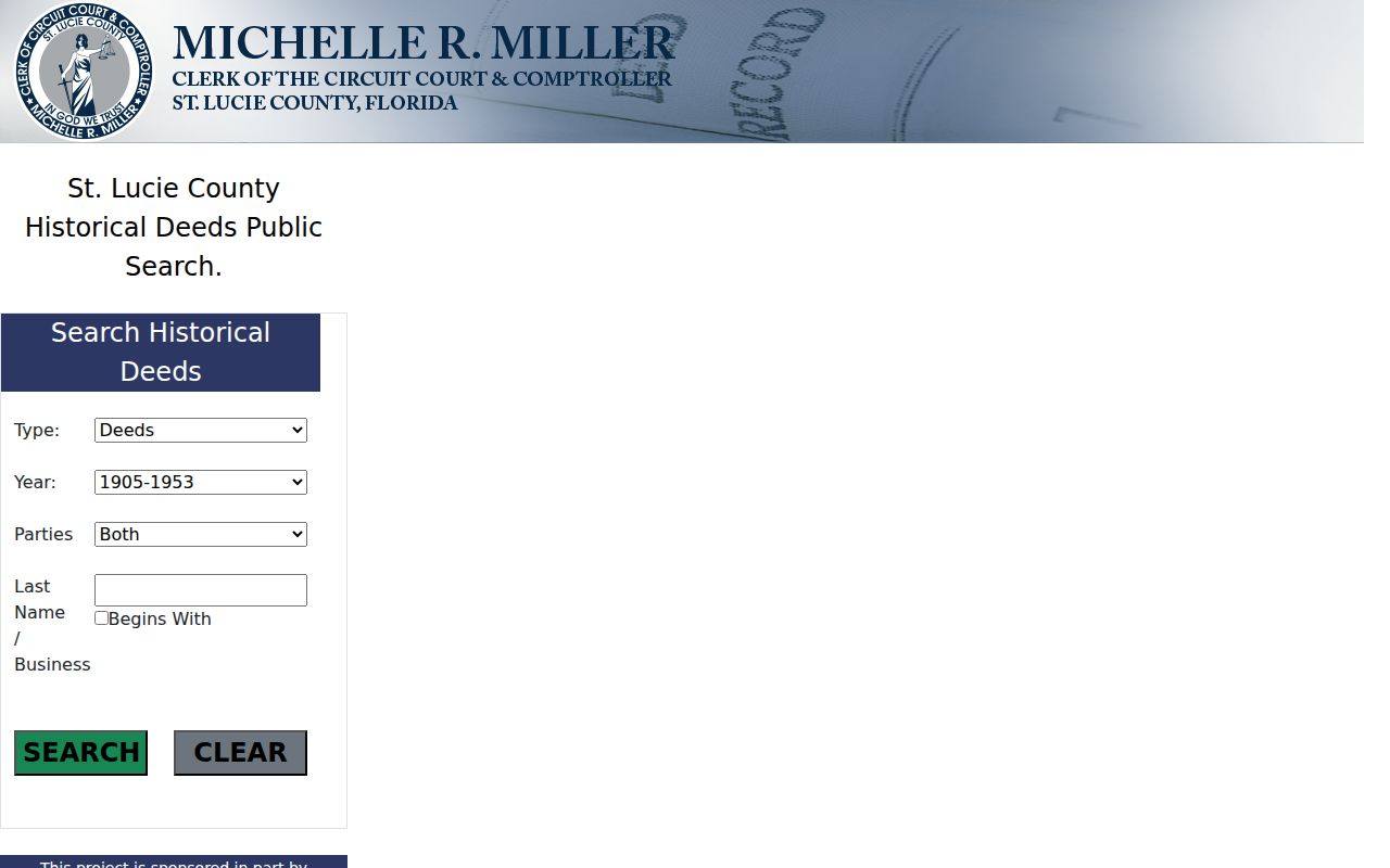
Its type, year, party, and surname controls help follow the legal chain when modern street labels are less useful.
Permits Along St. Lucie Streets
Permit evidence belongs with the office that governed the property. The county portal mainly serves unincorporated land. Port St. Lucie maintains a separate address search, while Fort Pierce routes building, lien, zoning, and site-plan records through city systems and requests.
The Port St. Lucie property search accepts House Number, Street, Direction, Section, Block, and Lot. A Property KEY opens permit history. Inspect both current and Legacy address rows when both appear. A red address can flag an issue, but it does not prove fault, current title, or residence.
The linked portal appears below as the second successful image assigned to this page.
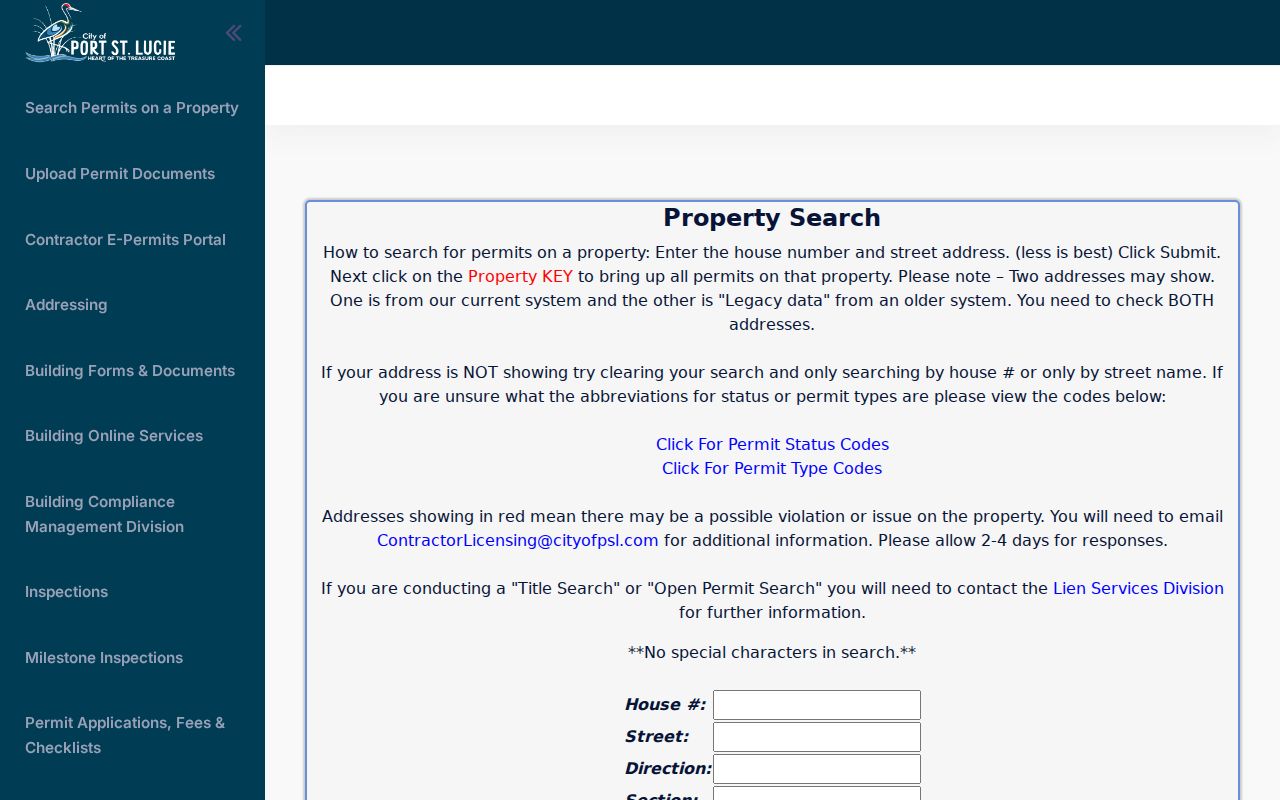
Separate street and plat fields are useful when one full formatted address misses a legacy record.
County files remain available through EnerGov, the Building and Code lobby, and a chapter 119 request. Port St. Lucie and Fort Pierce accept requests through their clerks by web, in person, email, mail, and phone; Port St. Lucie also lists fax.
St. Lucie Postal Boundaries
ZIP and postal-city labels deliver mail; they do not settle local jurisdiction. ZIP 34982 has a Fort Pierce postal identity but includes Port St. Lucie addresses. Picking a permit office from the mail line alone can therefore send a search to the wrong custodian.
Port St. Lucie's Addressing Division maintains addresses inside city limits after plan or plat approval and county recording. It may consider a change for a corner lot's front-door orientation or a sound numbering problem. Owners cannot freely choose numbers. When a street label is uncertain, compare the parcel, municipal boundary, and deed description.
Note: No authoritative countywide renumbering year was found, so keep parcel and lot identity instead of inventing a local chronology.
Historic St. Lucie Streets
Past address research has a much thinner year pattern than the parcel roll. NARA verifies Fort Pierce directory volumes for 1916, 1918, 1920 through 1923, 1927 through 1928, and 1931. The gaps matter. No listing in an unverified year cannot prove that a resident left.
Ten May 1924 Fort Pierce Sanborn sheets add building shape, use, and street context between the 1923 and 1927 directory points. A map does not establish the legal owner or each resident. The historical collections and entry method belong in the St. Lucie County city directory; here they add one dated clue to an address chain.
Limits of St. Lucie Streets
No official street directory identifies every renter, child, guest, or household member. DMV addresses are restricted. Utility and delivery lists were not verified as public people directories. Protected voter addresses and confidential parcel details can also be suppressed under Florida law.
Lawful use. Use St. Lucie County address records only for lawful personal research. Never use a street search to stalk, harass, intimidate, or harm anyone.
Commercial compilations may merge stale owner names, resident claims, and postal labels. Treat that category as a lead, not proof. Official custodians remain best for confirming a precise record, its date, and its access limits.